-
 play_arrow
Cree Nation Radio 103.5 FM Cree Nation Radio 103.5 FM
Land Use Planning
BACKGROUND
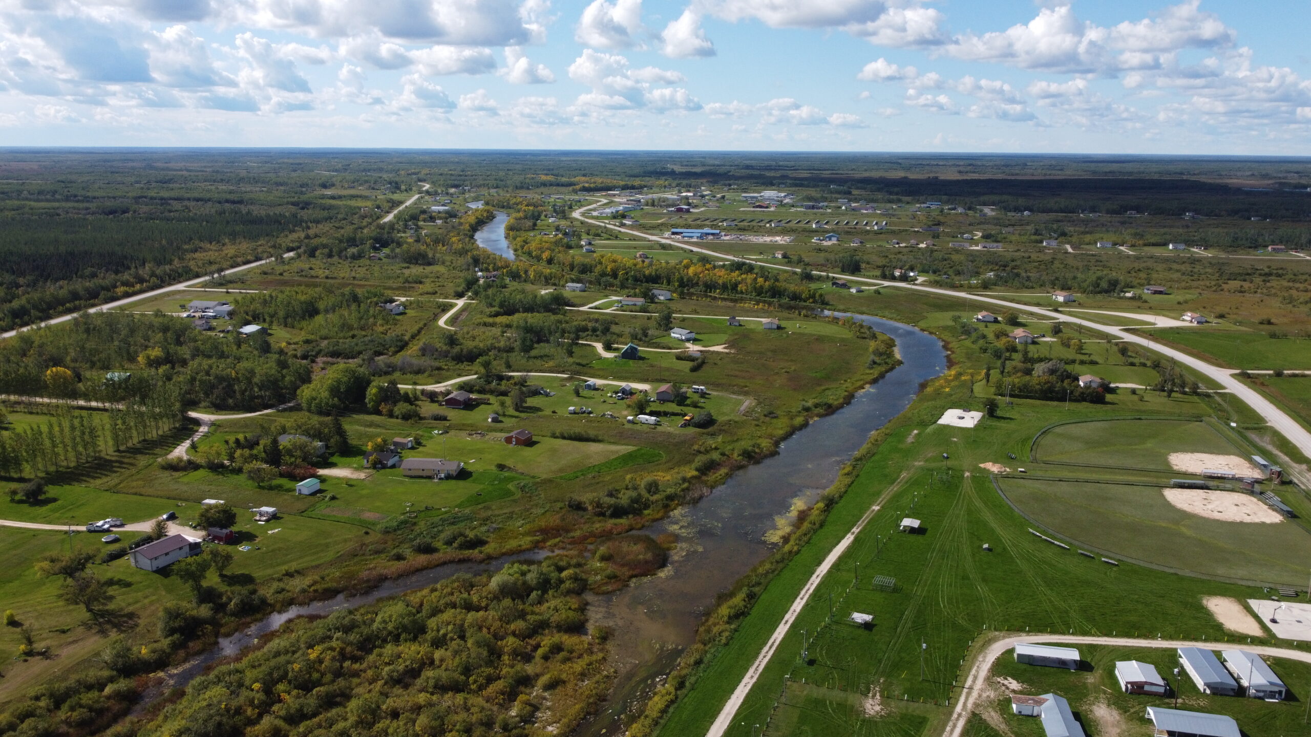
In 2016, Fisher River Cree Nation (FRCN) obtained funding from INAC Lands and Economic Development for a three-year land use planning project. Our Land Use Plan will help us to guide short- and long-term development on our lands, and it will build on our 2010 Community Plan that has acted as our roadmap for development over the past seven years.
FRCN has contracted HTFC Planning and Design (HTFC) to work with us to help undertake the planning activities associated with this Plan. This is a continuation of the existing relationship in planning between FRCN and HTFC (formerly Hilderman Thomas Frank Cram).
PROJECT GOALS
The three-year community planning process will help Fisher River Cree Nation to achieve the following goals:
Develop a Land Use Plan to be used by FRCN to make decisions about short- and long-term land management.
Establish a strategy to assess FRCN lands to determine possible use of our Reserve land (for example, cultural and traditional use, public and recreational use, commercial development, new housing development, and other opportunities for uses of land and resources).
Support responsible planning through a community-driven approach. The community will be engaged at all levels and stages of the planning process. This will allow community members to participate and agree on appropriate use of FRCN’s land, water, and other resources.
Update the 2010 Fisher River Community Plan (also produced by a partnership of FRCN and HTFC) based on new development, population growth and current community priorities.
Pave the way for land use policies and by-laws to be developed in conjunction with the Fisher River Land Code. These policies and by-laws will serve to protect and enhance the usability of lands and water for community purposes.
CURRENT PROGRESS
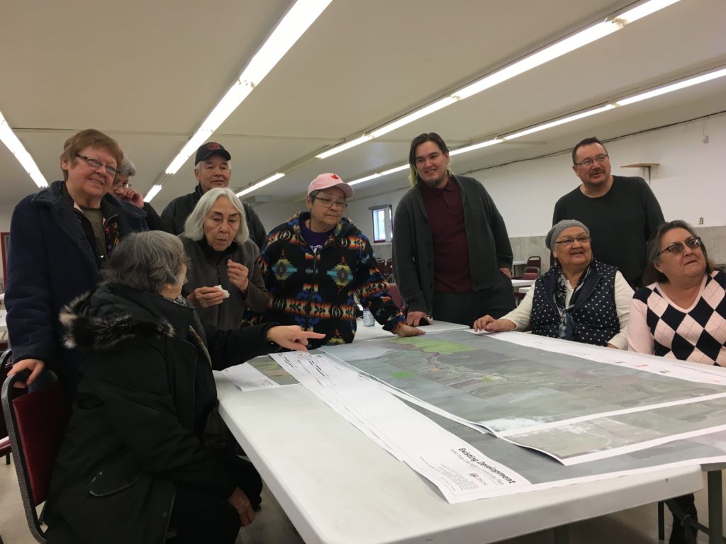
A community meeting for the Fisher River Land Use Plan was held on March 6, 2018, which included an information presentation followed by an interactive open house where members could provide comments on goals and policies relating to land use on Fisher River reserve land. The Land Use Plan includes Goals and Policies for these topics:
General Development Policies
- Overall Community
- Water & Land
- Energy, Infrastructure & Transportation
- Housing
Land Use Policy Areas
- HAR – Harvesting Areas
- AGR – Agricultural Rural Areas
- CUL – Culture & Recreation Areas
- RES – Residential Subdivision Areas
- TWN – Townsite Area
- IND – Industrial & Waste Areas
- FWS – Former Waste Site
Leading up to this meeting, the Land Use Plan Steering Committee (which includes Chief and Council, the FRCN Lands Manager, the FRCN Director of Operations, FRCN Elders, FRCN youth, and other representatives from the community at large) met regularly to review findings and develop these plans and policies. These plans and policies were based on what was heard from community Elders, Youth and members during the Land Use Plan Meetings held throughout the plan process, and on information gathered from past community studies, analysis of community information, and on community vision and goals.
In June 2017, the Planning Team completed the Land Use Plan Background Report, which included a terrain analysis, demographic information, a 20-year population projection, an infrastructure assessment, and a review of land tenure on FRCN Reserves. The Background Report also identified opportunities and constraints for land use and development for Fisher River IR 44 and IR 44A.
NEXT STEPS
Based on what we heard at the March community meeting, the Planning Team is refining the draft land use policies and policy areas, which will become the heart of the Fisher River Land Use Plan. A draft of the Plan will be available in spring 2018.
For more information and regular updates on the Plan, keep checking back on the Fisher River website.
REPORTS
- Opportunities-for-Agriculture-Feb-1318-R
- 16-026-Fisher-River-Cree-Nation-Background-Report-June-1417-DIGITAL-R
FREQUENTLY ASKED QUESTIONS ABOUT LAND — USE PLANNING
Q: What is Land Use Planning?
A: Land use planning is a way for communities to organize and control the use and development of land.
Planning helps communities to make decisions about how land in the community should be used. It involves thinking about what the community wants to do, looking at different ways to do it, and then choosing the best way.
Land use planning looks to the future: at how our community will change and grow in the years to come and it helps us to get ready for this change. Land use planning is also concerned with the present: at how our land is currently used, at today’s land-related problems and it helps us to find ways to solve these problems. Land use planning is also interested in the past: in planning for the future, we want to respect traditions, culture and our community’s historical use of the land.
Land use planning will help us make decisions regarding the use and development of our land, including:
Roads
Housing
Community uses such as schools, health facilities, recreation, social services, parks
Business opportunities
Industrial land, such as warehouses, fuel storage, manufacturing potential
Servicing such as water supply, waste treatment (sewage, recycling, garbage)
Q: Why do We Need a Land Use Plan?
A: Land use planning can provide many benefits to communities. Some of the reasons communities get involved in planning are:
To Prepare for the Future – Land use planning helps communities to anticipate future community needs and prepare for future growth and change.
To Save Money – Land use planning can help communities keep the cost of new development and services as low as possible. For example, a plan can make sure that new houses are located to make the best use of available land and roads are laid out in an efficient manner.
To Avoid Land Use Conflicts – Through planning, communities can separate uses of land which can conflict with one another because of noise, odour, hazardous materials or other potential nuisance (e.g., noise from diesel generators can be a nuisance for residents in nearby homes).
To Protect Important Features – Land use planning can protect historic, cultural and natural features, (e.g., access to water, sacred sites, cemeteries, sensitive ecosystems, historic sites, views, natural areas).
To Address Environmental Concerns – Land use planning allows for development to be planned to avoid sites which are unsuitable for development because of environmental limitations (e.g., unstable soils, areas with a risk for flooding, poor drainage, contamination).
Q: How will the community be involved in the Land Use Plan?
A: It is important to hear from many different voices during the planning process. Community members will be engaged at workshops, small group meetings, surveys or questionnaires, and community meetings. Community members will be kept informed of the planning process through regular updates on FRCN’s website, radio station, social media, and newsletters.
The planning process will also be supported and guided by a Steering Committee composed of individuals that are representative of the community as a whole. The Steering Committee includes:
Chief and Council (5 members)
2 Elders from the community at large
2 Youth from the community at large
2 Other Community Members
The FRCN Director of Operations
The FRCN Interim Lands Manager
Q: What is the land use planning process going to achieve?
A: The land use planning process will produce the following desired outcomes:
Enable the FRCN membership to confirm a community vision and guiding principles to work towards the utilization of their lands and resources.
Create a plan that considers and respects the social, economic, geographic, and political realities of the FRCN Community.
Build a foundation for economic development while respecting and preserving land from a cultural and historical viewpoint.
Produce a “living” document that is frequently reviewed and amended to incorporate change and growth.
Assist in decision-making on land management issues for overall community development
Guide the direction to be taken regarding the effects of potential annual flooding on developed land.
Increase knowledge of the value of FRCN lands and resources, which will be identified through environmental and physical assessments. This knowledge will contribute to more informed decision-making, which better meets the land-use needs of the community.
Completion of maps of all FRCN reserve lands, which incorporate future plans, current land use, and traditional land use that took place in the past.
Strengthen accountability and transparency measures of the FRCN Chief and Council, as supported by the members of Community.
Fisher River Cree Nation is a community in which our history, language, traditions, and culture are paramount to who we are as a people. We will protect and maintain the spirit and intent of the treaties and our inherent rights. Fisher River will be a self-sustaining progressive community with a strong and accountable government. We will provide an environment where all people are healthy, safe, and respected.
CONTACT US
- 204.645.2171
- Box 367, Fisher River, MB R0C1S0
- Media Inquiries - [email protected]